pile.org
2017 E5 walk: Prologue
I’m writing this journal for several audiences:
- For friends and family, who’ve asked what the walk was like. I doubt this will answer all the questions, but maybe it’ll answer some of them.
- For strangers (hello), who might want to learn something about this under-documented part of the E5, or the GR trails I walked along, or what it’s like to do a long-distance walk as an English-speaker in France.
- For myself, to help me remember the walk. I wrote a tiny handful of notes on the first couple of days I walked, but was generally exhausted by the end of the day, and writing on a small phone screen wasn’t especially easy, so I gave up early.
This journal is not a travel guide. I didn’t inspect any alternate accommodations, nor did I really vet the ones I did stay at; I didn’t consider the stamina or food needs of anybody else; I didn’t visit many sights, and didn’t do much deep research into the history of the trail or the places I visited.1 That said, I do hope this might be useful as the sketch or outline for your walk, or inspires you to take a different one.
If you have any comments, questions, or concerns about this journal, please email me.
I don’t know where I learned about the network of European long-distance hiking trails. It seems like the kind of thing Jason Kottke would have posted about, but I can’t find any evidence that he did. In any case, in 2015, I got it into my head that I should walk the length of the E5 trail.
The E5 runs from the western tip of France, in Brittany, to Mont-Saint-Michel. From there, it passes just south of Paris, then up the Seine to near Dijon. It then arcs east to the Swiss border, then up along the northern border of Switzerland. It continues east, briefly into Germany and Austria, before turning south to cross the Alps into northeastern Italy, ending in Verona.2 It’s about 2,000 miles long.
I thought, briefly, about hiking a comparable American trail instead — the PCT would be the obvious one, though the Appalachian Trail’s length is closer to the E5’s. But unlike those wilderness trails, the E5 is mostly rural (passing through the occasional town or city); I liked the idea of needing to carry no more than a two or three days’ food with me. The route seemed achievable, too: The maps seemed to suggest that the first difficult stretch would be crossing the Vosges in eastern France. The second difficult stretch was the only one that I was concerned I might not be able to accomplish: The crossing of the Alps reaches about 10,000′ at the highest point, but more than that, it’s a relentless, days-long series of climbs and descents.
So. Why did I choose to do this?
It’s been four years since the walk, nearly six years since I decided to do it. It was definitely not certain things: I did not want to escape my family; nor was I burnt out at work. But I still don’t know why. The mostly-tongue-in-cheek answer I sometimes give is that this was my “mid-life crisis”, instead of getting a girlfriend or a stupid car. Not an explanation, but an observation, is that I’d been walking a lot (by modern urban standards), lunchtimes at work and occasional walks across the city. And maybe I needed to detox from the internet, too? (None of those are very satisfying explanations.)
Before making any plans, I asked Meghan if I could do this. She immediately answered yes. And I’ve since wondered whether she regretted that: This would end up putting a huge burden on her, taking care of the kids and the house with essentially no support. I did ask several times again over the next year and a half, and she reaffirmed each time, and I had to take what she said at face value. I will always (happily) be in her debt.3
I’d been told (and now having done it, I agree) that the only way to really get in shape for a long walk is to do a long walk. Really, how do you practice for walking more than 15 miles per day, carrying 20+ pounds on your back, without doing that?
I did my best. Once I’d decided to do this, I settled on a backpack pretty quickly, and then put a couple bags of rice in, and padded it out with clothing, to vaguely resemble a loaded pack. I wore it to work every day, and for an hour at lunch; I had a route where I would walk for an hour, including an extra trip up and down the Lenora Street stairs and then back up the Pike Street Hill Climb. After work, I’d take the bus home to the bottom of my hill, then walk up that. I ended up in pretty decent shape, certainly much better than when I’d started.
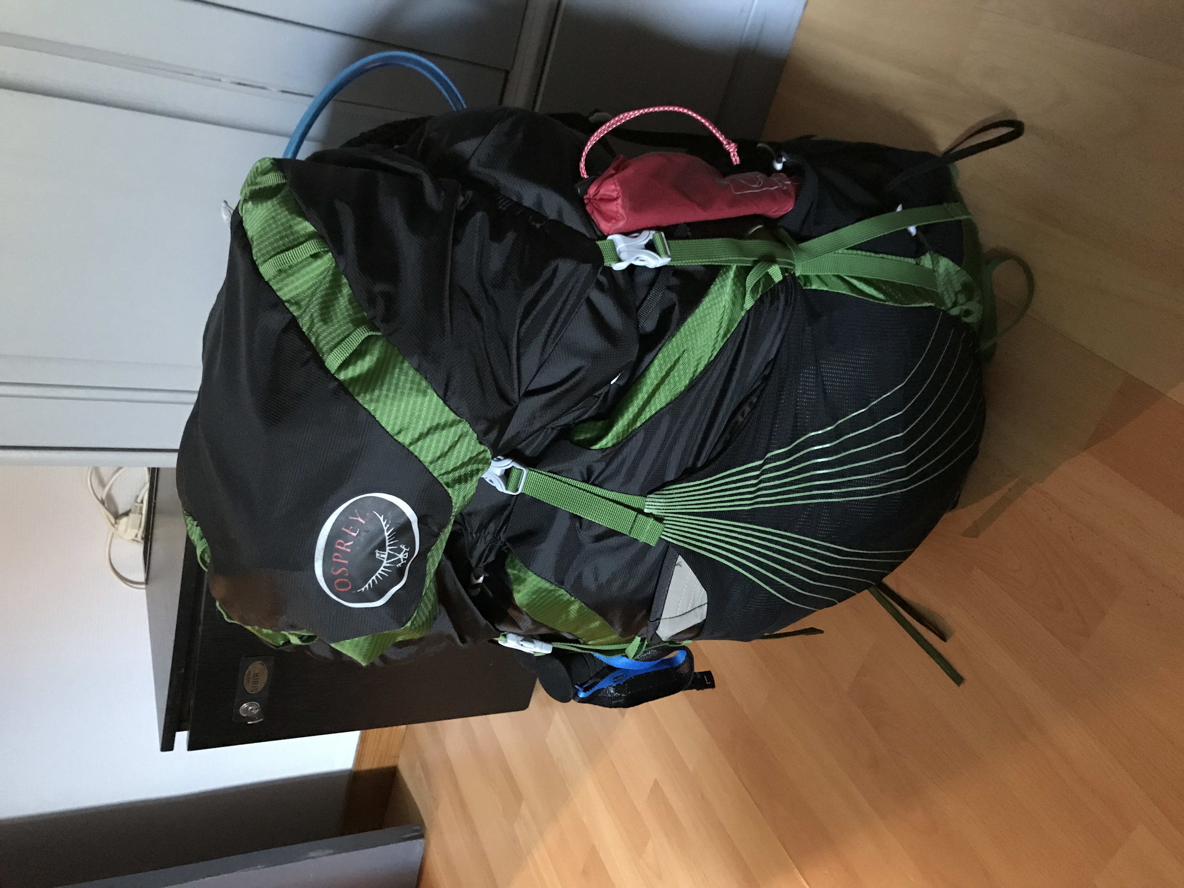
Another part of preparation was getting the rest of my gear; it ended up weighing a little more than 20 lbs., not counting consumables like food and water, or the clothes I wore. I’m sure many people couldn’t care less, but for those who are interested, I wrote about my gear in some depth.
I also made sure I visited all my various doctors before I left — I didn’t want some preventable problem cropping up where I couldn’t communicate. This was uneventful, except that my podiatrist prescribed orthotic inserts for my shoes, to keep my feet from … I don’t know, bending the wrong way or something.4
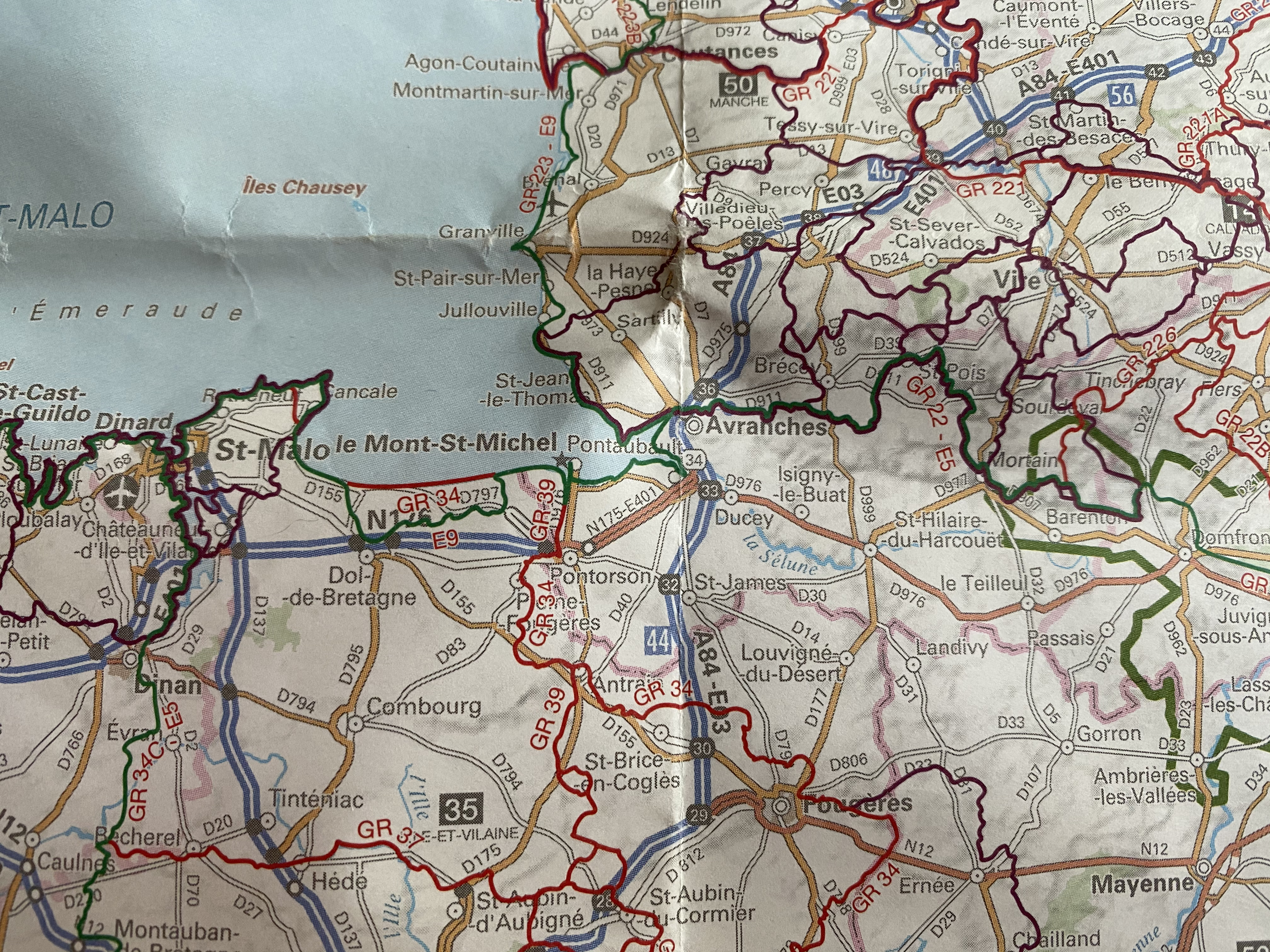
For maps, I used the IGN’s (roughly the French equivalent of the USGS) hiking maps. I’ve included an IGN map on each page, linking to a fully-featured version (I recommend their maps over Google’s or Apple’s, most importantly because IGN’s consistently include hiking trails).
The start of the walk was the Pointe du Raz; it’s the southern of the three westernmost peninsulas of mainland France, in Brittany. On IGN maps, the trails I followed are solid magenta (the GR 34 at the start, but changing to other trails as I walked). Zooming in to about 1 : 34,110 is good to follow the route (though you’ll need to scroll to see a full day’s walk), and 1 : 17,055 to look at more detail.
I started in early April. I had a very approximate sense of how far I could travel in a day5, and was aiming to cross the Alps in August, when the pass was likeliest to be clear. (The pass doesn’t require any technical gear or special skills to cross in the summer; August is the month when there’s typically no snowpack, and when the weather is least likely to interfere.)
I left Seattle on the afternoon of Wednesday, April 5, 2017. I stopped in Iceland for about an hour, transferring to a second flight to Paris, where I landed early in the afternoon (local time) on the 6th. I got a local SIM card and a phone charger suitable for European outlets, and then caught a fast train to the city of Quimper6, where I spent the night in a room I had found on AirBnB with a kind and generous host.
-
This isn’t quite true: I did the occasional wikidive into, say, the Duchy of Brittany and its heraldry, or the history of piracy in the Saint-Malo region. I didn’t do anything formal, though, and certainly didn’t take notes or find anything that you couldn’t find with a few taps on a keyboard. ↩︎
-
From what I can tell, this last stretch, from Lake Constance (on the Swiss/German border) to Verona, must have been the original route of the E5, with the French and western Swiss portion added on later. One of the only maps I could find of the French portion was of all France’s GRs, for example in this stretch from Dinan to Domfront; most documentation on the E5 covers the Alpine stretch, and most of it is in German. ↩︎
-
A healthy relationship is built on a ledger sheet of credits and debits, right?7 ↩︎
-
I suppose they worked: My feet didn’t hurt (at least no more than seemed appropriate for walking on them all day, every day, while carrying 20+ pounds on my back), though I did end up having trouble with my ankles. ↩︎
-
It turned out to be pretty accurate, perhaps a touch conservative. ↩︎
-
The train got in late because it hit a lamb that had been on the tracks. The train stopped for perhaps 30–45 minutes, and then slowly limped the rest of the way to Quimper. ↩︎
-
(The ledger is actually to determine who is winning in the relationship.) ↩︎