pile.org

2017 E5 walk, day 32: Saint-Malo to Pointe du Grouin

Section 8, Day 32
St-Malo
2°1′34.9″W
48°38′46.2″N
Pointe du Grouin
1°50′43.8″W
48°42′15.5″N
low 45 °F
high 62 °F
52,609 steps
20.1 miles

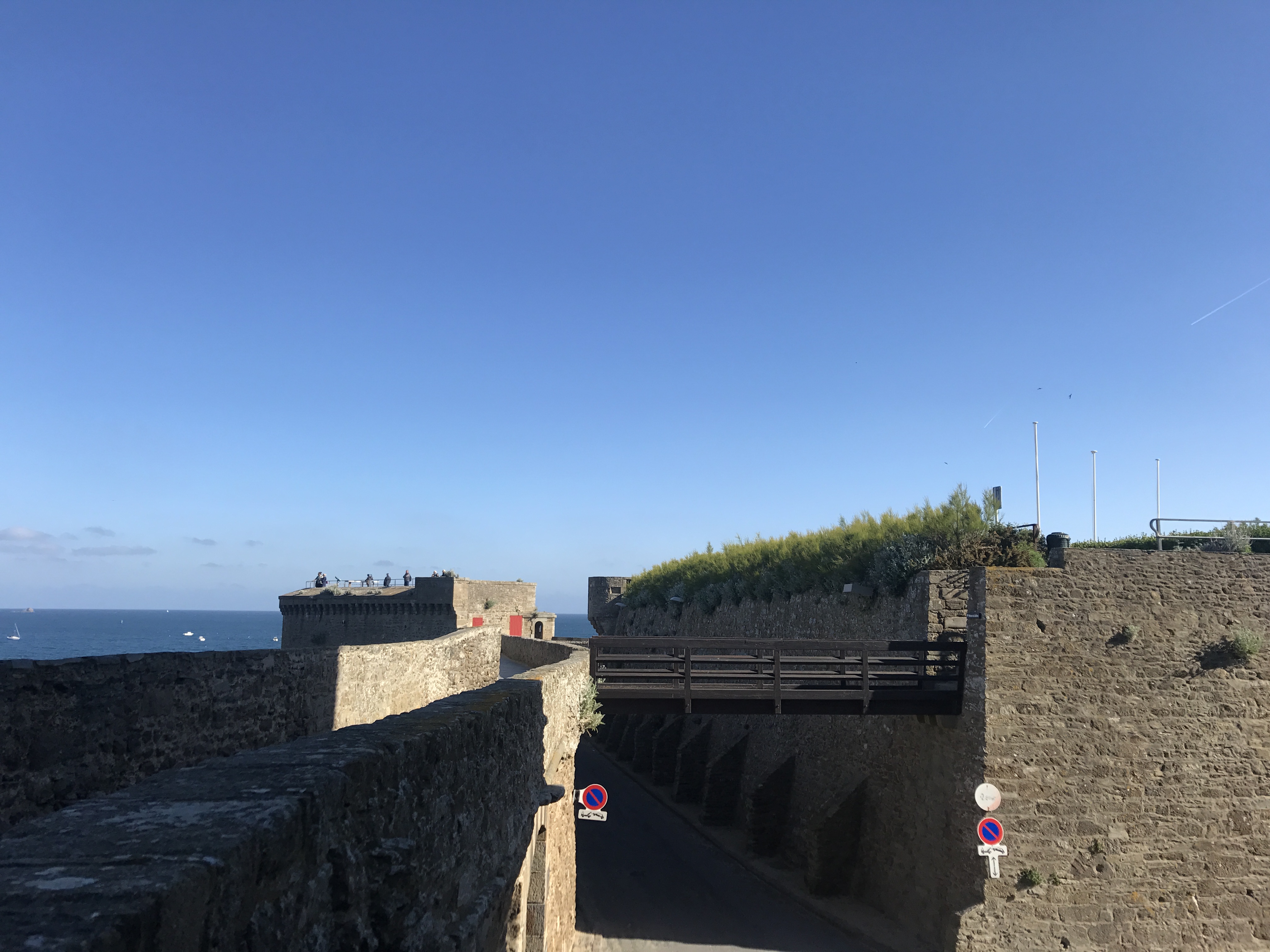
I got up early and headed back to Saint-Malo. The GR 34 ran along the top of the city’s walls, so (once I found my way up) I circled the city from above, with my first really good view of the English Channel.1
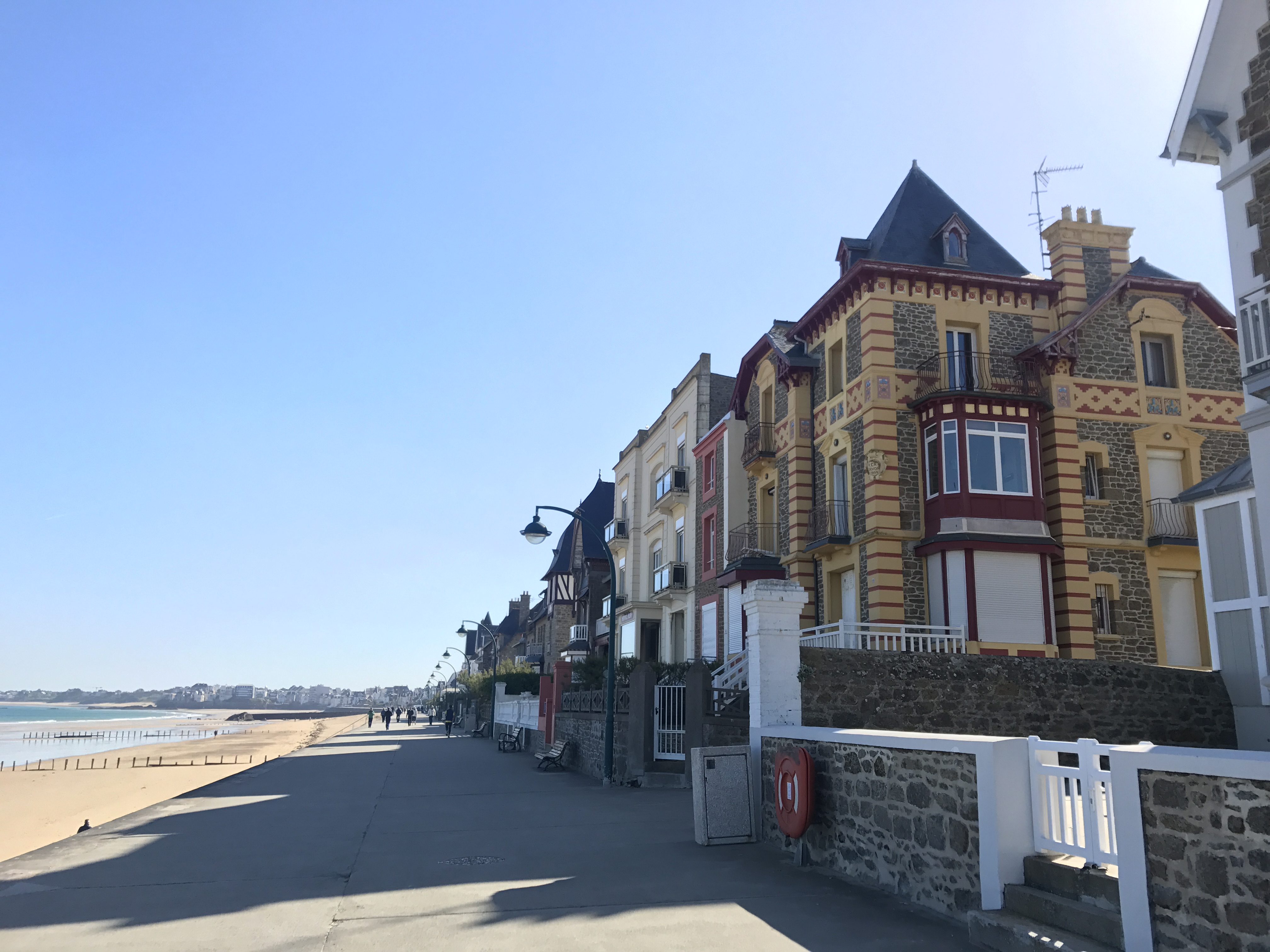
The top of a stone wall heads north, waist-high stone barriers on either side preventing pedestrians from easily falling more than ten feet to the road below.  The road passes between the wall and an inner wall; the inner wall has greenery growing on top, and a wooden bridge crosses between it and the outer wall.  Ahead, there is some kind of low fortification, with people on top.  Beyond is an open body of blue water, with a few boats visible.  The sky is blue with the hint of clouds at the horizon; the sun must be low, judging by the angle of the shadows.
Atop Saint-Malo’s walls.

At the north­eastern corner of the old city, the trail descended back to the ground. I stopped for bread and pastries at Bakery Maison Hector, and followed the trail out the gate to the east. It led along the Grande Plage (“Great Beach”), and it reminded me intensely of Southern California beaches — a wide boardwalk, with houses jammed together up alongside, each one different than its neighbors.

A sidewalk runs wide and flat to the northeast.  Immediately to its right are a series of houses, one next to another, with low stone walls between each and the sidewalk.  Each house is different; the nearest is three stories tall, edges and floors yellow with red, with mortared stone elsewhere.  It looks like it is relatively new construction that wants to seem older.  In the distance down the sidewalk are perhaps a dozen people; to the left of the sidewalk, below, is a sandy beach, with the tide high.  In the far distance might be a cape with buildings on it.
Houses along the Grande Plage.

At various times over the course of the day, the trail went on the sandy beach, which (as before) made me quite anxious: I was having enough trouble with blisters without getting sand into my shoes and socks and grinding against my feet. Fortunately, as before, it turned out that I was able to walk carefully enough that none got into my shoes, or at least it wasn’t enough to cause a problem.

After the Grande Plage, the trail started to climb up and down seafront cliffs, reminiscent of the first days, though not so high above the ocean, and interspersed with beaches. It occasionally struck inland for short stretches; along one of these was Crêperie La Guym’s, where I stopped for lunch.

A dirt trail runs west past an old concrete military pillbox, overgrown with vines and moss.  Behind the pillbox is brush on an ascending slope.  The trail leads to a rough series of stairs leading up that same slope, curving away to the left past some trees.
There were more signs of German occupation, this one starting to get pleasantly overgrown.
To the northwest across the sand, a rocky promontory rises up at the water’s edge; at high tide, it is probably cut off from the land.  On top are what look like old fortifications, with wind-blown trees and a well-kept house inside.  The sky overhead is a rich, perfect blue.
As it was low tide, Fort du Guesclin was, theoretically, accessible on foot. I didn’t visit.

Several hours and several beaches later, I finally rounded the Pointe du Grouin. Just a short distance after that, I reached the night’s campground, camping municipal de la Pointe du Grouin, through an anonymous gate in the trail-side fence. The campsite was surprisingly busy — I didn’t have trouble finding a space, but more spaces were occupied than not, which I hadn’t experienced for a week and a half. I had a sandwich for dinner, and turned in early after the long day.

Map of the day’s route.

  1. Of course the French don’t call it the “English” anything; it’s la Manche (“the Sleeve”). ↩︎